de Dodengang
The Trench of Death
Location
From Ieper take the N 369 in the direction of Diksmuide. On reaching the centre of the town turn left onto the N35 (towards Veurne). As you cross the river Ijzer, you will see the IJzertor Tower on your left.
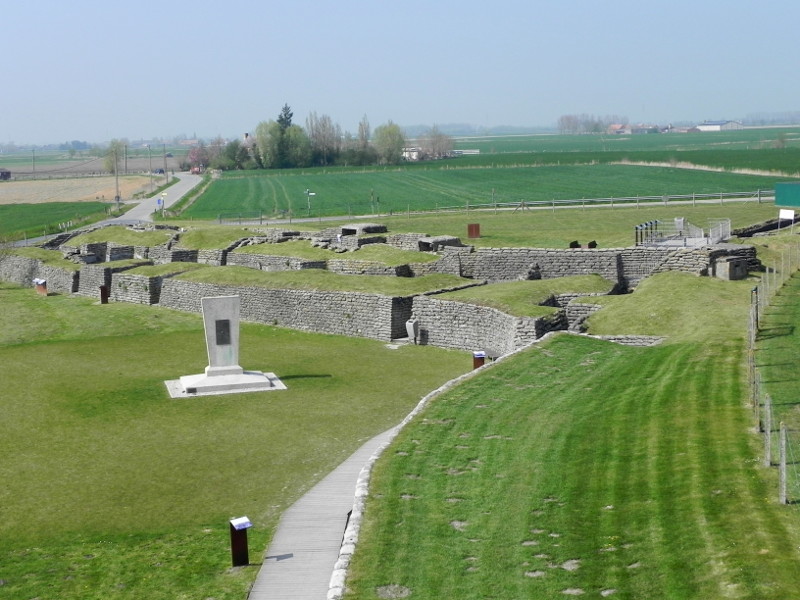
Immediately after crossing the river turn right along the Ijzerdijk in the direction of Stuivekenskerke (there is also a brown tourist sign for the Dodengang). This preserved trench system known as le Boyau de la mort in French is the only Belgian Great War site still in existence.
| GPS | N | E | OSM |
|---|---|---|---|
| Decimal | 51.045880 | 2.843142 | Map |
History
In the final days of the race to the sea at the end of 1914 the Belgians flooded the area between here and the coast. However, at this bend in the IJzer river the flooding was at its limit and it was impossible to leave the area unguarded.

The town of Diksmuide was taken by the Germans on 11th November 1914 after a gallant defence by the Belgians and a detachment of 6,000 Fusiliers Marins of the French Navy under Amiral Ronarc’h.
Despite the flooding the Germans managed to retain a foothold on the Belgian side of the IJzer at a set of large petroleum tanks. This bridgehead and observation post formed a serious threat to the Belgian defenders who attempted, several times, to take the position by storm. Each time they were driven off.
In May 1915 the local commander Generaal-Majoor Jacquet, of the 3rd Division, ordered his men to begin a sap (engineers’ trench) out towards the tanks. At almost the same moment the Germans began building their own southwards !
The two systems eventually ‘met’ and the opposing sides found themselves no more than fifty metres apart. The sap now became a double trench, though in this case the trench was built up with sandbags (called: patriots) as it was impossible given the proximity of the inundated fields to dig down.
The first trench created, alongside the IJzer, in June was crenellated in order to prevent the Germans from being able to fire down its length — it also faced the Germans on the far side of the river.
The second, inner trench however is in a straight line along which ran a Décauville 60cm gauge railway track.
French uses the word Boyau for a communications trench, as opposed to a front line Trenchée.
In September the Belgians built the Knight’s redoubt (Redoute du Cavalier) at the base of their trenches as a cautionary measure against any attempted breakthrough.
It was soon found though that the Belgian system ran too far north leaving it vulnerable to German harrying attacks. Because of that, it was decided, on 11th October 1915, to blow a hole in its side about 275 metres from the 16 km marker (on the river by the entrance) allowing a section to be flooded (between the German Bunker and the trenches — it has since been filled in).
By 1917 the head of the Belgian system contained a double bunker with covering machine gun posts that soon earned it the nickname of The Mousetrap.
The trench system would be held continuously by the Belgian Army from henceforth until the commencement of the victory advance in September 1918.
A three day roulement system was set up and most regiments of the Belgian Army would spend time here, in one of their most dangerous and exposed positions.
On 15th October 1918 the Germans finally retreated from the IJzer.
The Centre and Trenches
Immediately after the war the position was declared as an official war site but it was only through the intervention of the Royal Touring Club of Belgium that the trenches were preserved from destruction.
The site has since been taken over by the Ministry of Defence. A lot of work has been carried out to refurbish the trenches and create an excellent visitors’ Centre.
The 11de Bataljon Genie of the Belgian Army (Engineers) carried out a number of restoration programmes to restore and maintain the trenches in their former state — only in concrete!
| Opening Times | Openingsdagen |
|---|---|
| Covid-19 | Closed/Gesloten/Fermé |
| 1st April – 15th November | 01 april – 15 november |
| Every day 10:00 to 17:30 hours |
Elke dag 10u00 tot 17u30 |
| 16th November – 31st March | 16 november – 31 maart |
| Tuesday & Thursday 09:30 to 15:30 hours |
Dinsdag en donderdag 09u30 to 15u30 |
| Closed | Gesloten |
| 25th December – 1st January | 25 december – 01 januari |
| Entrance Fee | Tarief |
| 4€ Adult | |
Visiting the site will take between an hour and ninety minutes.
On the first floor of the visitors’ centre (lift available) you are introduced to the Battle of the Yser and the inundations ordered by King Albert I. Further displays recount the story of the Petroleum Tanks and the Belgians attempts to take them.
The tanks were the main reason why the trenches were built and displays tell of their creation and the life of the soldiers manning them.
The visitor can now head to the second floor where a panorama of the surrounding countryside is obtained. A large 1917 photograph helps you orientate yourself and see just how the countryside has changed since the war.

with its Belgian helmet
As you enter the trenches it needs to be remembered that you are also walking towards the German positions. It was not a simple case of the Belgians on one side of the river and the Germans on the other. The Belgians were exposed on three sides.
There are numerous descriptive panels around the site explaining exactly what you are looking at.
On the wall of one of the bunkers on your left you will see a small commemorative plaque dedicated to Major Félix Bastin, a physician with the 8ste Belgian artillery. He was killed by a shell on 4th November 1917. A heavy bombardment had caused one of the shelters to collapse, trapping a soldier underneath it. Realising that the wounded soldier needed to have his legs amputated immediately, in order to keep him alive, Bastin went out personally during the bombardment. Although he managed to save the soldier, Bastin was struck by a shell and died almost instantly. He is buried in the Belgian military cemetery at Oeren (Alveringem).
All replenishments and reinforcements had to be carried out by two foot bridges directly under the eye of the Germans across the inundated fields. One of them towards Lettenburg was used to bring in reinforcements and supplies whilst the other towards the village of Kaaskerke (which is just behind the trenches) was used to bring up the sandbags which were badly needed to repair their positions.
At the far end you will find one of the Royal Touring Club of Belgium’s Demarcation Stones marking the limit of the German advance. It was unveiled by King Albert I in 1922.
These stones which can also be found across France come in three forms : Belgian, French and British — each with its own helmet on top. In general they were intended to mark the limit of the Germans’ advance in 1918 but some in Belgium commemorate particular events from earlier in the war — as in this case.
Although outside the official site, the German bunker can now be accessed from within.
Some photos of the trenches
Click on the thumbnail for a larger version